Due to the nature and length of the Great Divide Mountain Bike Route, careful attention must be paid to the travel direction (North-Bound vs. South-Bound) and the time of year (usually between June and October) for riding this route.
Weather can play a significant role in the experiences on the Great Divide Mountain Bike Route. Freezing temperatures and snow on high altitudes, the pronounced increase in thunderstorms and rainfall during the North American monsoon, high winds on the great plains, and high temperatures during summer are just a few examples of weather that will be experienced during the trip.
The GDMBR is over 3,083 miles (4,962 kilometers) running from Jasper in Alberta, Canada to Antelope Wells in New Mexico, United States. Because of this long length, and therefore passing very different terrains, the weather on this route will include everything you can imagine from rain, hail, snow on high(er) altitudes, and high winds, to extreme temperatures. All varying from very mild to severe storms.
On a large part of the route, many high mountain passes have to be passed. To name a few examples: Elk Pass – Alberta (6,250 ft / 1,905 m), Galton Pass – British Columbia (6,108 ft / 1,862 m), Union Pass – Wyoming (9,212 ft / 2,808 m), Marshall Pass – Colorado (10,842 ft / 3304 m), Boreas Pass – Colorado (11,482 ft / 3,499 m), Ute Pass – Colorado (9,524 ft / 2,902 m), and the highest pass on the route is Indiana Pass, Colorado which has an altitude of 11,913 ft (3,631 m). Weather on these passes can be unpredictable and can include strong winds, hail, snow, and thunderstorms.
The weather will not only have a possible impact on a person’s physique, such as lightning during thunderstorms, hypothermia because of low temperatures, and dehydration because of high temperatures, but it also has an impact on the road surfaces. Some mountain passes only become passable when temperatures reach a certain level (that is why the main window is between June and October). There are also sections that turn impassable after heavy rain. The road becomes so muddy that thick layers of mud force the bike to a halt by blocking rotations of the wheels, or seriously hindering the drive train. Especially during monsoon season, this is a known factor that should not be taken lightly. Fortunately, there are route alternatives defined for these sections.
Weather Window
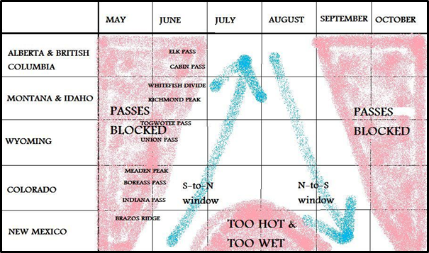
Weather conditions not only dictate what gear to bring (especially in terms of clothing), but it also impacts the route (road surfaces, and route direction). Starting too early or too late and mountain passes will be closed. Monsoon season in New Mexico means a-lot-of mud. Deciding upon a South-Bound or North-Bound direction also has to take these weather conditions into account. Dutch cyclist Mathieu van Rijswick researched climatological data and assessed many blogs and journals to compile a graph on the weather window for both directions.

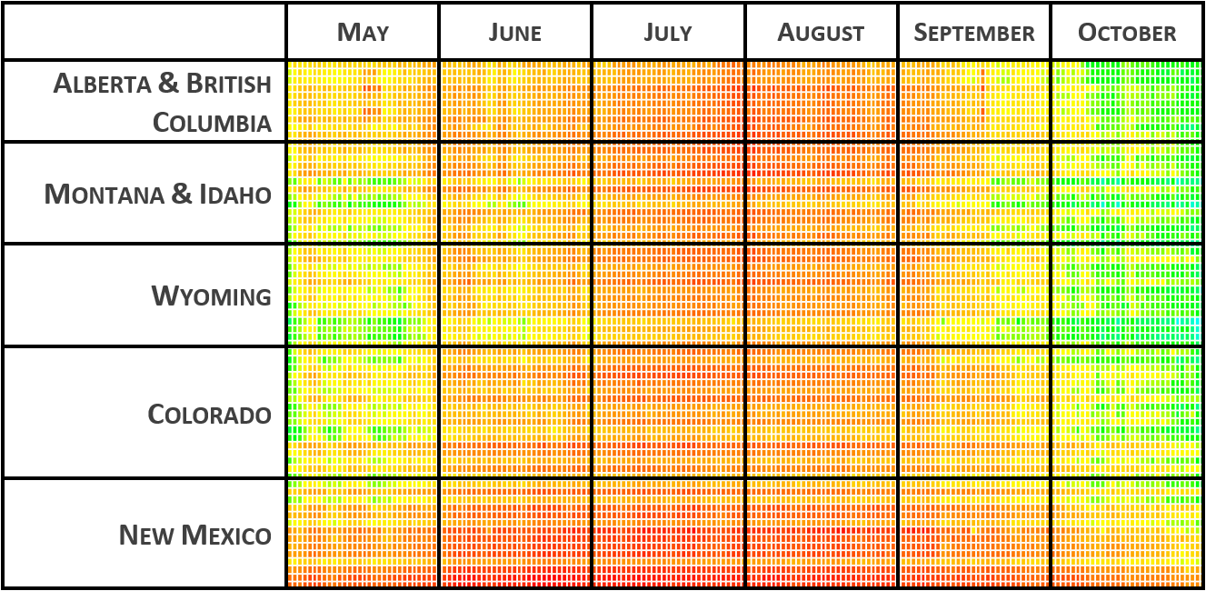
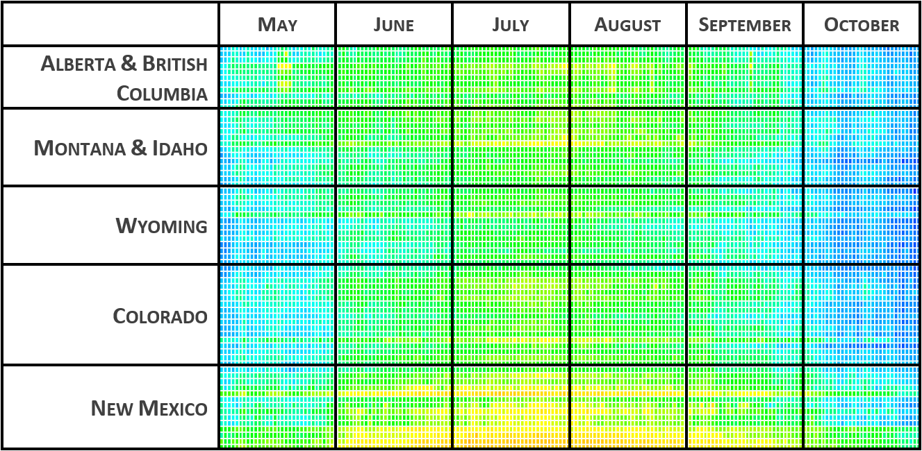
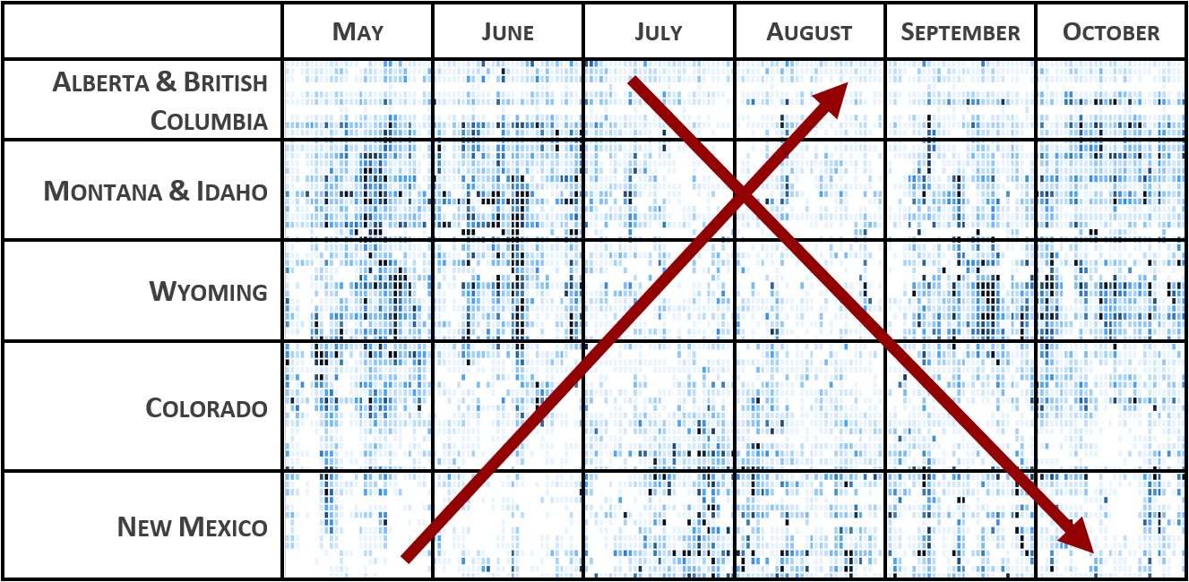
The blog post with more details about the graph is dated December 2012. For this writing, a similar analysis has been re-done based on historical weather data from 2016-2021. The historical weather data has been downloaded and combined from several online resources.


As expected, after analyzing the resulting graphs, it can be concluded that almost ten years later the overall conclusion of Mathieu still applies. The best window for South-Bound riders will be early July until early October. The best window for North-Bound riders is from late May until late August. These figures are based on averages of the last five years (2016-2021) and actuals can differ year-on-year.
When planning, one must take the expected duration of the trip into account. The example arrows in the last table would be more or less steep depending on the expected trip duration. Completing the trip in 3-4 weeks would result in a more steep arrow compared to completing the trip in 2-3 months.
Route Direction
The GDMBR can be ridden in both a South-Bound and North-Bound direction. Most cyclists choose to ride the route South-Bound and start in Banff National Park in Alberta, Canada. The reason is probably because the route was initially promoted South-Bound only, and another important factor is that the commonly used starting point, Banff National Park, is easier to get to from a logistics point-of-view. In the overview below there are some pros and cons for either direction.
South-Bound
- more people riding the south-bound route
- more convenient logistics to / at the start
- more unpredictable weather at the start
- physically easier (flatter) at the end
- desert at the end
- later in the season for lower temperatures in the southern deserts and less impact of monsoon rains
- possibly fall colors in the forests
North-Bound
- physically easier (flatter) at the start
- high(er) temperatures in the beginning
- more natural water sources available due to earlier start
- more unpredictable weather at the end
- more convenient logistics at the finish
- earlier in the season for lower temperatures in the southern deserts and less impact of monsoon rains