Western Wildlands Route
Admin Jun 17, 2024“The 2,700-mile Western Wildlands Route (WWR, formerly known as the Wild West Route) offers bikepackers a non-technical riding experience through the vast expanses of wild and public lands in the Intermountain West. Nearly 70% of the route is on public lands - 18 National Forests, 6 National Parks and Monuments, and 4 areas with Bureau of Land Management National Conservation Lands designation.”, according to Bikepacking Roots. This route took us 12 days, 8 hours, 40 minutes, and 9 seconds of cycling time to cover 4312 km (2679 miles), including 47660 m (156372.46000000002 ft) elevation gain, with an average speed of 15 km/h (9 mph), reaching a maximum speed of 63 km/h (39 mph) on Saturday, June 1, 2024. During cycling, there was a minimum temperature of 0 °C (32 °F) on Thursday, May 30, 2024, and a maximum temperature of 50 °C (122 °F) on Friday, June 7, 2024.
Continue readingGreat Divide Mountain Bike Route
Admin Sep 12, 2022“The Great Divide Mountain Bike Route (GDMBR) is Adventure Cycling’s premier off-pavement cycling route, crisscrossing the Continental Divide in southern Canada and the U.S. This route is defined by the word “remote”. Its remoteness equates with spectacular terrain and scenery. The entire route is basically dirt road and mountain-pass riding every day. In total, it has over 200,000 feet of elevation gain. Nearly 2,100 miles of the route is composed of County, Forest Service, Bureau of Land Management (BLM), and Canadian provincial unpaved roads.”, according to the Adventure Cycling Association.
Continue readingLatest posts
Day 33: The highest pass on the route
EvE Sep 2, 2022Today we rode from a cabin at the base of the climb to Indiana Pass, Colorado, US to Horca, Colorado, US. Sunny weather with very little clouds. Road conditions included gravel roads only. Highlights of the day include climbing Indiana Pass, meeting trail angels and their support. Riding statistics: on Friday, September 2, 2022, day 33 on the route, it took 11:17h (06:27h moving time), between 7:23 and 6:40, to cover 96.62368 km (60 miles), including 1660 m (5446 ft) elevation gain, with an average speed of 12.0 km/h (7.5 mph), while reaching a maximum speed of 43 km/h (26.7 mph). During this ride the average temperature was 26 °C (79 °F) with a minimum of 9 °C (48 °F) and a maximum of 39 °C (102 °F).
Continue reading
Day 32: Kevin’s Cabin
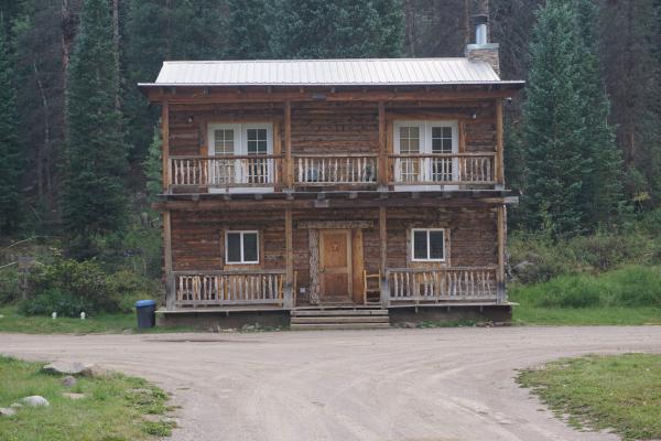
EvE Sep 1, 2022Today we rode from informal campground 8km before the top of Canero Pass, Colorado, US to a cabin at the base of the climb to Indiana Pass, Colorado, US. Sunny weather with little clouds. Road conditions included paved roads, gravel roads, and jeep tracks. Highlights of the day include climbing Canero Pass, the jeep tracks after La Garita, and the cabin were we will stay for the night. Riding statistics: on Thursday, September 1, 2022, day 32 on the route, it took 11:17h (06:27h moving time), between 7:23 and 6:40, to cover 95.15808 km (59 miles), including 991 m (3251 ft) elevation gain, with an average speed of 15.0 km/h (9.3 mph), while reaching a maximum speed of 47 km/h (29.2 mph). During this ride the average temperature was 27 °C (81 °F) with a minimum of 3 °C (37 °F) and a maximum of 49 °C (120 °F).
Continue reading
Day 31: No formal campground today
EvE Aug 31, 2022Today we rode from Tomichi Creek Trading Post (Sargents), Colorado, US to informal campground 8km before the to of Canero Pass, Colorado, US. Sunny weather with some clouds. Road conditions included paved roads and lots of gravel roads. Highlights of the day include climbing Cochetopa Pass and the ride up to our informal campground. Riding statistics: on Wednesday, August 31, 2022, day 31 on the route, it took 09:02h (07:04h moving time), between 7:52 and 4:55, to cover 112.22083 km (70 miles), including 1260 m (4134 ft) elevation gain, with an average speed of 16.0 km/h (9.9 mph), while reaching a maximum speed of 45 km/h (28.0 mph). During this ride the average temperature was 27 °C (81 °F) with a minimum of 11 °C (52 °F) and a maximum of 38 °C (100 °F).
Continue reading
Day 30: Salida
EvE Aug 30, 2022Today we rode from Salida, Colorado, US to Tomichi Creek Trading Post (Sargents), Colorado, US. Sunny weather with little clouds. Road conditions included paved roads and different sorts of gravel roads (smooth & difficult surfaces). Highlights of the day include having a lunch break on Marshall Pass and meeting all kinds of different people. Riding statistics: on Tuesday, August 30, 2022, day 30 on the route, it took 07:42h (05:03h moving time), between 9:26 and 5:08, to cover 67.09585 km (42 miles), including 1125 m (3691 ft) elevation gain, with an average speed of 13.0 km/h (8.1 mph), while reaching a maximum speed of 40 km/h (24.9 mph). During this ride the average temperature was 32 °C (90 °F) with a minimum of 20 °C (68 °F) and a maximum of 44 °C (111 °F).
Continue reading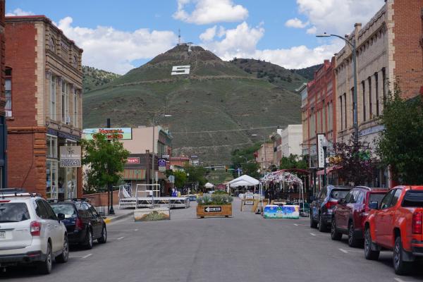
Day 29: A downtown visit
EvE Aug 29, 2022Today we rode from Hartsell, Colorado, US to Salida, Colorado, US. Sunny weather with little clouds. Road conditions included some paved roads and good gravel roads. Highlights of the day include a very good a long downhill, and the town of Salida. Riding statistics: on Monday, August 29, 2022, day 29 on the route, it took 09:34h (05:05h moving time), between 7:27 and 5:03, to cover 81.45383 km (50 miles), including 785 m (2576 ft) elevation gain, with an average speed of 16.0 km/h (9.9 mph), while reaching a maximum speed of 47 km/h (29.2 mph). During this ride the average temperature was 30 °C (86 °F) with a minimum of 5 °C (41 °F) and a maximum of 43 °C (109 °F).
Continue reading
Day 28: The knee says NO
EvE Aug 28, 2022Today we rode from Silverthorne, Colorado, US to Hartsell, Colorado, US. The day started with sunny weather, eventually overcast, and later thunderstorms (we have not been rained on today). Road conditions included paved roads and gravel roads. Highlights of the day include Boreas Pass (one to second highest peak on the Great Divide Mountain Bike Route). Riding statistics: on Sunday, August 28, 2022, day 28 on the route, it took 09:16h (07:14h moving time), between 9:06 and 6:22, to cover 111.22728 km (69 miles), including 1191 m (3908 ft) elevation gain, with an average speed of 15.0 km/h (9.3 mph), while reaching a maximum speed of 47 km/h (29.2 mph). During this ride the average temperature was 21 °C (70 °F) with a minimum of 11 °C (52 °F) and a maximum of 34 °C (93 °F).
Continue reading
Day 27: Radium
EvE Aug 27, 2022Today we rode from Radium, Colorado, US to Silverthorne, Colorado, US. Sunny weather with afternoon thunderstorms. Road conditions included easy gravel roads and paved roads. Highlights of the day include climbing Ute Pass. Riding statistics: on Saturday, August 27, 2022, day 27 on the route, it took 11:02h (07:32h moving time), between 7:18 and 6:20, to cover 115.86983 km (71 miles), including 1764 m (5788 ft) elevation gain, with an average speed of 14.0 km/h (8.7 mph), while reaching a maximum speed of 49 km/h (30.4 mph). During this ride the average temperature was 18 °C (64 °F) with a minimum of 3 °C (37 °F) and a maximum of 35 °C (95 °F).
Continue readingAbout
This is my personal blog on which I keep family and friends updated about my bikepacking adventures.